
Minnesota (Fort Snelling) weather for the year 1837
Cool Spring and Early Summer, Wet Autumn (graphic)
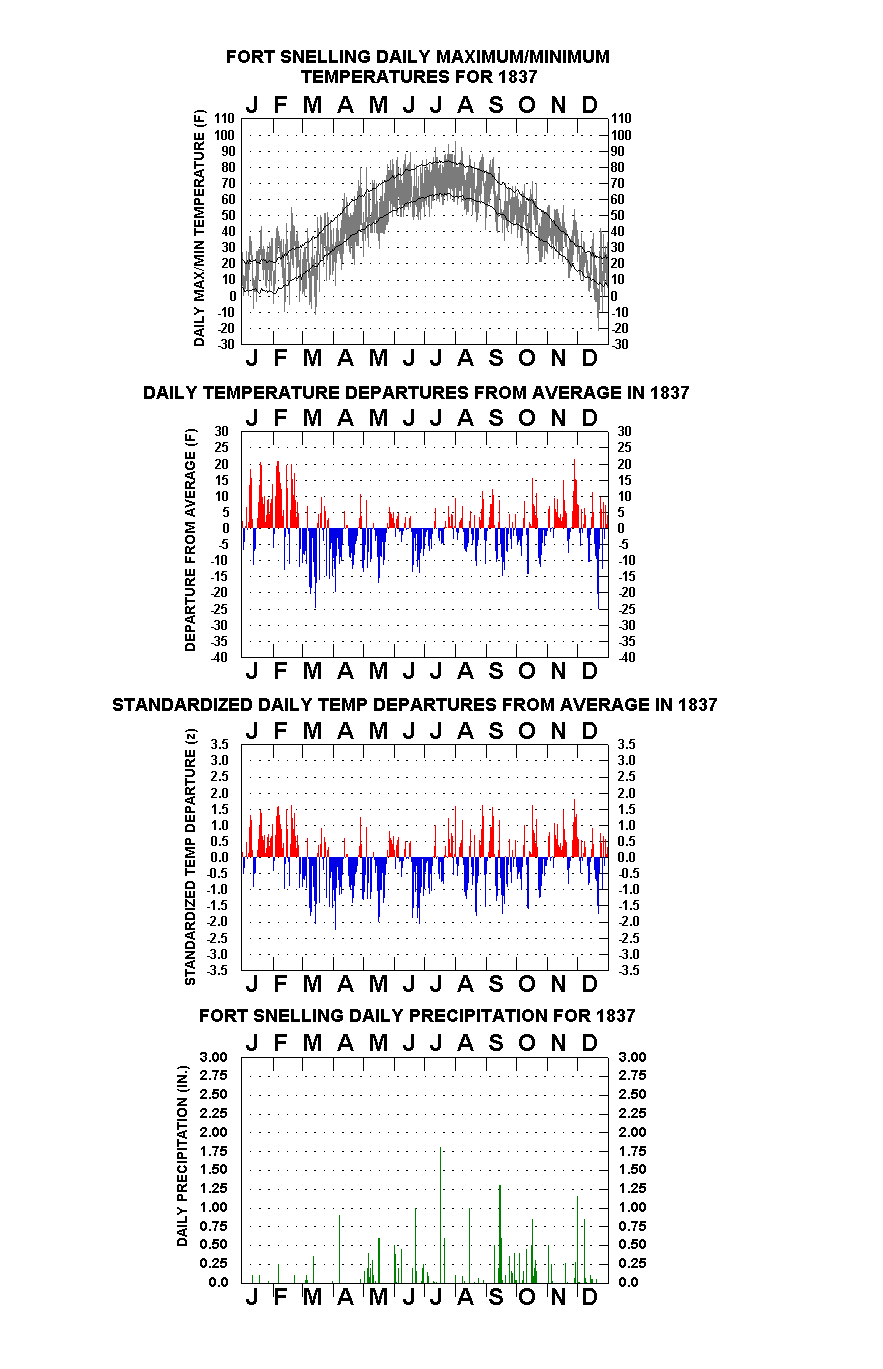
Unseasonably cool weather in Spring and early Summer to go with a wet Fall marked Fort Snelling’s weather during 1837. For the second straight year, the rivers’ breakup from the Post vantage point was delayed into April, and May and June were each as cool as any experienced over the previous seventeen years. Generally seasonable temperatures after mid-summer, though, resulted in a higher annual mean temperature (44 F) than either 1835 or 1836. Fall (September-November) had more precipitation-days than any such period in the record thus far, and early December brought two major storms. Total yearly precipitation received by the new rain gauge in its’ first full year of service was just over 24 inches.
Mild and Dry January/February – Seemingly compensating for late December’s frigid weather, unseasonably warm (and dry) conditions predominated both January and February ’37. January (mean temperature: 18 F), had just two morning temperatures at zero or lower, the coldest “only” minus 8. Precipitation consisted of four light snows totaling about 2 inches. Most afternoons after mid-month approached or surpassed 32 F, the 19th reaching 42 F for the month’s warmest. On the 28th, Surgeon J. Emerson wrote with no great exaggeration: “weather extremely mild for the season during the entire month”. February (mean temperature: 24 F) had 20 afternoons at 30 F or above, and just five mornings below zero. Total melted precipitation was .35 inches, the result of a 2-3 inch wet snowstorm on the 6th (temperatures thawing all day) and a light rain on the 22nd. Eight of the first eleven afternoons were thawing, two reaching the low 40’s, but a brief dose of arctic cold dropped the mercury to –10 F on the 12th, the month’s coldest temperature. A week later, though, the mercury hit 54 F, balmiest February temperature in seven years; 50 F was also read on the next day, the 20th.
Another Retarded Spring – January and February any indication, it probably seemed that an accelerated spring advance was now to follow. Such would not be the case in 1837, as March, April, and May each brought consistent backward temperature spells. March (mean temperature: 23 F) was colder than February, a climatic feat that occurs about once every 30 years in these parts. Most mornings over the first fifteen days were below zero or nearly so, thawing afternoons occurring just twice. Following a 3-4 inch snowstorm on the 12th, the mercury plunged to -12 F on the 14th, coldest since late December and a new coldest-so-late-in-the-season mark. Moderating temperatures then set in, most subsequent afternoons in the 40’s, the 24th and 26th each reaching 50 F, but for the second straight year at month-end the rivers were still ice-locked. April (mean temperature: 40 F) was even colder than last year. The early part was very wintry, “high winds” from the north dropping the mercury to 6 F on the 3rd, the mid-afternoon temperature just 31 F. On the 7th, a “very severe snow storm” with additional high winds set upon the Post, nine inches left (applying the 1 inch of snow for every .10 inches of melted precipitation rule-of-thumb) to create the deepest covering of the whole season. This brought the season’s total to about 30 inches. Predominately fair, dry, but cool weather comprised most of the remaining days, freezing temperatures experienced almost nightly until near the close, most afternoons confined to the 40’s and 50’s. The Mississippi wasn’t entirely clear of ice until the 26th, the actual breakup date, not mentioned, likely some days earlier. Similar to a year ago, the spring’s first legitimately warm day came near the close, 78 F recorded on the 28th, light rain also falling for the first precipitation since the big snowstorm. May (mean temperature: 54 F) was the coolest in 18 years, persistently backward temperatures and frequent light to moderate rains predominating through mid-month. Freezing temperatures occurred as late as the 17th, 30 F noted on this date, the month’s lowest, 26 F, having come on the 1st. Ten of the first seventeen days had rain, totaling 2.65 inches, days with falls frequently having afternoon temperatures confined in 40’s with chilly northerly or easterly winds. As late as the 16th, rain and snow mixed was recorded. Warmer, summery weather made up the last week, afternoon readings exclusively in the upper 70’s to low 80’s, mornings generally in the 50’s. Diary notes had gardening commencing on the 3rd and potatoes being planted on the 11th.
Cool June, Relatively Light Summer Rains – Summer was generally pleasant in temperature with relatively light precipitation, total rainfall (7.36 inches) about 2/3rds of the modern-day “normal” as we know it. June brought the fifth successive month of unseasonable coolness, mean temperature (65 F) equaling 1824’s and 1834’s figures as the lowest since establishment of the Post. Just three afternoons got as warm as the mid-80’s, many others in the mid-70’s and cooler. Rain totaled 3.36 inches on eleven days. The mercury reached 87 F on the 17th for the month’s maximum, but the last thirteen days were the month’s coolest period, six of the afternoons in the 50’s and 60’s, a like number of readings between 48 F and 50 F at daybreak. History would be made this summer as a treaty was signed at the Post between the whites and the Sioux/Chippewa, the Indians ceding most of their lands east of the Mississippi [Lass, 1976]. Diary notes from Surgeon J. Emerson on 1st of June reported arrival of a steamboat from St. Louis with “Indian Amenities”, the inclusion of such a non-meteorological entry suggestive of a special intended purpose, perhaps a signing ceremony. July (mean temperature: 72 F) brought relatively cool temperatures over the first half, warm readings over the second. Rain fell on seven days to 2.68 inches. Continuance of late June’s cool pattern, the 1st was only 50 F at sunrise, most afternoons over the first week no warmer than the 70’s. Just a few others through the 20th were as high as the low 80’s. Only 0.27 inches’ rain fell over the first sixteen days, a “heavy thunder storm” on the 17th, however, dropping 1.81 inches. Warm and muggy weather prevailed over the last eleven, most afternoons in the upper 80’s to low 90’s, temperatures overnight dropping no lower than the mid-to-upper 60’s. August (mean temperature: 69 F) was also relatively seasonable in temperature with 1.32 inches’ rain, about half of normal. An inch of this resulted from a single “heavy thunder storm” on the 15th. July’s closing heat carried over and peaked on the 1st, 94 F recorded for the summer’s warmest, 90 F also occurring on the 7th. The last ten days displayed alternating autumnal and summery weather, the 22nd ranging from 47 F to 66 F, the 28th and 29th, however, each indicating low 70’s in the “A. M”. and mid-80’s readings in the “P. M”. Fall-like temperatures were back on the 31st, though, the observed daily spread 42 F to 69 F.
Wet Fall – Autumn brought seasonable to mild temperatures and generous precipitation falls, nearly 10 inches recorded over the three months. True to its usual form, September (mean temperature: 59 F) had a few warm and humid days early, much cooler (and rainy) weather prevailing after mid-month. Precipitation totaled 5.10 inches (about double of normal) on 12 days, all but one of these over the last eighteen. Temperatures over the 5th-8th reached the high 70’s to mid-80’s for the afternoons, nights in the 60’s to low 70’s, but similar to last year, heavy rains and cool temperatures set in around mid-month, 3.20 inches drenching the Post over the 14th-16th. The season’s first frost came on the 19th. The remaining days were cool but still wet, morning temperatures generally in the 40’s, afternoons in the high 50’s to mid-60’s. October (mean temperature: 47 F) was also rainy, 3.15 inches (about 50 % above normal) totaled on 12 days, all of the falls over the first three weeks. Just three afternoons got as warm as the upper 60’s, but a number of nights dropped no lower than the 50’s, most of these during the rainy periods. Observed temperature spread on the 17th was an unseasonably mild 60 F to 70 F (the latter the month’s highest reading), nearly an inch of rain falling during the day. The final ten were crisp and dry, most mornings in the 20’s, afternoons in the 40’s to low 50’s. November (mean temperature: 37 F) had steady relative mildness over virtually the whole month. Precipitation was 1.37 inches on seven days, nearly all of it rain. Afternoons were in the 40’s and 50’s on each of the first 20 days, the warmest (55 F) occurring twice during the first week and once during the third. The season’s first snow, less than 1/2 inch, came on the 21st, both this day and the 22nd subfreezing in their entirety. On the latter evening, the mercury dropped to 11 F for the month’s coldest temperature, but the last days were very mild, the 28th 53 F, one-third of an inch of rain falling on this day and the next.
Stormy Early December – December (mean temperature: 17 F) brought a quick onset of winter with two heavy storms over the first nine days. The first, a sleetstorm, pelted the Post over the night of the 1st-2nd, leaving 1.15 inches’ water content. With an icy landscape now present, a heavy snowstorm (8-9 inches) next followed over the 8th-9th. Temperatures, mostly seasonable up to this point, then began to trend downward, the season’s first zero temperatures read on the 18th and 20th. Another more intense arctic intrusion brought -20 F on the 22nd, and the 26th was -10 F, but start of a heavy thaw that would carry over into the first days of 1838, New Year’s Eve reached 41 F.